Ham Radio on Jarvis.
There have ONLY been 2 DXpeditions to Jarvis post WWII:
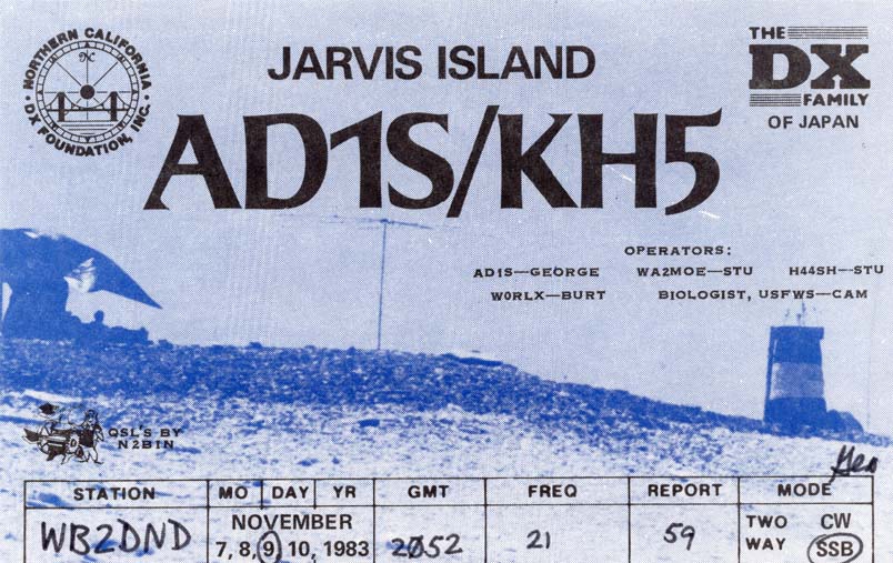
AD1S/KH5 in November 1983 which made 16,800 QSOs:
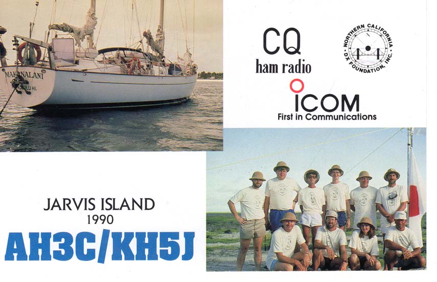
AH3C/KH5J in April 1990 which made 55,000 QSOs:
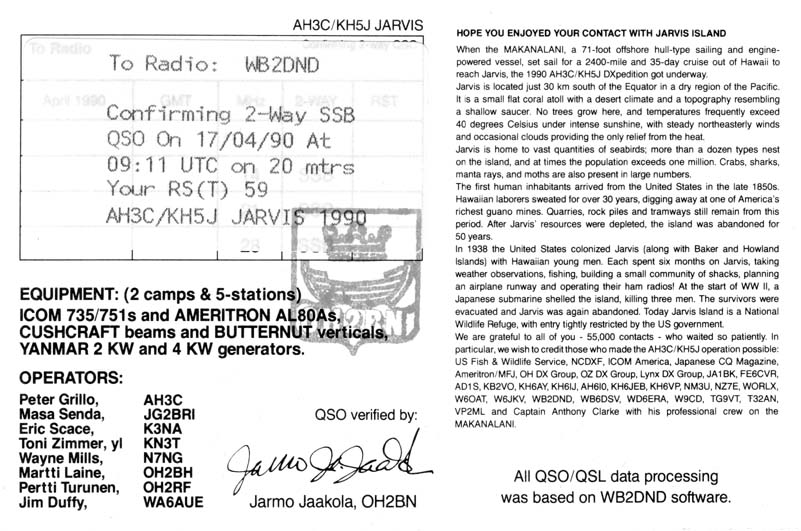
Note that on this QSL that they used the WB2DND software. WB2DND is now N1DG who looks forward to going there himself.
When the Dateline DX Assocation decided it was time to try another Jarvis DXpedition in 2021 we discovered the old Compatibility Determination had expired and therefore the USFWS needed to do another study as to whether or not Amateur Radio was compatible with the mission to protect the Jarvis NWR. Luckily after 2 years that determination was made that indeed, our activities were compatible. After additional months of negotiating what our DXpedition would look like, and in no small way how we could limit our impact on the Reserve, a decision was made to issue a Special Use Permit. The use of the RIB concept and our agreement to take 3 scientists with us to allow USFWS to conduct needed research on the Island were the factors making this possible. Our organization wishes to thank the management of the Pacific Remote Marine National Monument for their efforts in making this possible.
The budget for Jarvis Island 2024 exceeds $485,000. Please contribute and help this happen. Each QSO will cost the group roughly $5.00
Jarvis Island
Jarvis Island (formerly known as Bunker Island or Bunker's Shoal) is an uninhabited 4.5 km2 (1.7 sq mi) coral island located in the South Pacific Ocean, about halfway between Hawaii and the Cook Islands. It is an unincorporated, unorganized territory of the United States, administered by the United States Fish and Wildlife Service of the United States Department of the Interior as part of the National Wildlife Refuge system. Unlike most coral atolls, the lagoon on Jarvis is wholly dry.
Jarvis is one of the Central Line Islands (Palmyra is one of the Northern Line Islands) and for statistical purposes is also grouped as one of the United States Minor Outlying Islands. Jarvis Island is the largest of three U.S. equatorial possessions, which include Baker Island and Howland Island. Jarvis, in addition to being part of a different Island group from Palmyra is also separated from Palmrya by the division of terrority by a treaty between the US and Kiribati signed in 2013. It deserves it's own country status.
Jarvis Island was discovered in 1821 by Captain Brown on the British ship Eliza Francis. Alfred G. Benson and Charles H. Judd took formal possession of the island in 1857 in the name of the American Guano Company of New York. Later that year, Commander Charles Henry Davis of the USS St. Mary surveyed the island and formally claimed it for the United States. Jarvis Island was mined for guano in the late 1800s. Under the Guano Act of 1856, it became a U.S. possession. Jarvis was abandoned in 1879 after many tonnes of guano had been removed. The United Kingdom annexed the island in 1889, but did not further develop the mining operations. In 1906 it was leased to the Pacific Phosphate Company of London, but again mining was not further developed. The United States reoccupied and reclaimed Jarvis in 1935 and it was placed under the jurisdiction of the Department of the Interior on May 13, 1936 (Executive Order 7368). The new colonists were evacuated from the island in 1942 following attacks by Japanese forces, and the island has remained mostly uninhabited since then. In 1957-1958, Millersville, on the western side of the island, was occupied by scientists during the International Geophysical Year. Since June 1974, the island has been administered by the U.S. Department of the Interior Fish and Wildlife Service as part of the National Wildlife Refuge system.
The American Equatorial Islands Colonization Project was a plan initiated in 1935 by the United States Department of Commerce to place U.S. citizens on uninhabited Howland, Baker, and Jarvis Islands in the central Pacific Ocean so that weather stations and landing fields could be built for military and commercial use on air routes between Australia and California. Additionally, the U.S. government wanted to claim these remote islands to provide a check on eastern territorial expansion by Japan. The colonists, who became known as Hui Panalāʻau, were primarily young Native Hawaiian men and other male students recruited from schools in Hawaii. In 1937, the project was expanded to include Canton and Enderbury the Phoenix Islands. The project ended in early 1942 when the colonists were rescued from the islands at the start of the War in the Pacific.


For a detailed history of Jarvis and the pre WWII Colonization project see:
https://www.jarvisisland.info/panalaau_memoirs
During the 7 years of the colonization project the colonists were were in touch with their families via ham radio. Some of the QSLs from Jarvis:

